August 26, 2024
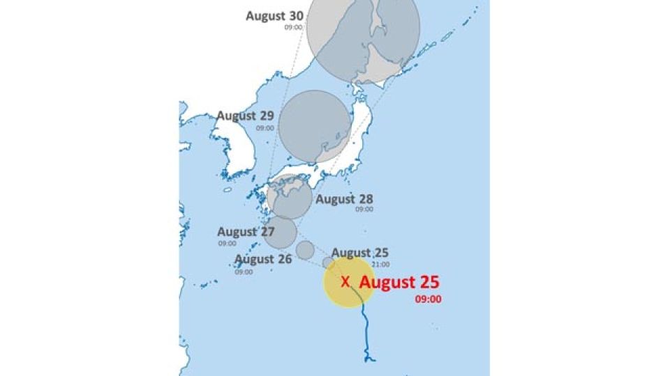
TOKYO – The Japan Meteorological Agency said Sunday morning the strong Typhoon Shanshan was heading north over the sea near the Ogasawara Island chain and may approach western and eastern Japan on or after Wednesday.
The agency said the typhoon, also known as Typhoon No. 10, is expected to bring strong winds and high waves to western and eastern Japan, urging residents to take greater caution.
The agency also advised winds are expected to gradually strengthen in western Japan, with violent winds forecast to hit the area Tuesday.
The typhoon is anticipated to have a maximum wind speed of 25 meters per second and a maximum instantaneous wind speed of 35 meters per second in the Shikoku region Tuesday. In the Kinki region, it will have a maximum wind speed of 23 meters per second and a maximum instantaneous wind speed of 35 meters per second. The agency said violent winds and sea storms are expected in the aftermath in western Japan.
According to the information on the location of the typhoon released by the agency at 6:45 a.m. Sunday, the typhoon was moving northwest along the south of Japan at a speed of 30 kilometers per hour at 6 a.m. Sunday. The central atmospheric pressure was 980 hectopascals, and the maximum wind speed was 35 meters per second near its center with a maximum instantaneous wind speed 50 meters per second, causing a storm with a wind speed of 25 meters per second or higher within a radius of 55 kilometers from the center.
In the latest information on the typhoon path released by the agency, the typhoon is expected to become “very strong” with a maximum wind speed of 45 meters per second near its center at 3 a.m. Tuesday, when it will move toward the Kyushu region. The central atmospheric pressure is also expected to become 950 hectopascals.
The typhoon is forecast to then change course northward and become “strong” with a central atmospheric pressure of 955 hectopascals and a maximum wind speed of 40 meters per second near its center at 3 a.m. Wednesday, when it will be much closer to western Japan.

