
August 20, 2025
ISLAMABAD – Underneath the fatal climate events that have hit the country’s mountainous north are factors that are controllable yet ignored every year, every time.
We’ve seen these headlines before. Heard anchors screech body counts as if they’re in a competition for the highest number. Hundreds of lives lost, thousands displaced, homes swept away and losses that won’t ever be compensated.
Pakistan is once again in the midst of a ruthless monsoon season, which began in late June, and on the radar is the country’s mountainous north — Khyber Pakhtunkhwa, Gilgit Baltistan, and Azad Jammu and Kashmir.
Last week, unprecedented flash floods left behind a trail of wreckage in Buner, Swat, Shangla, Mansehra, and beyond. A week before that, Muzaffarabad bore the brunt of monsoon rains. Almost a month back, 37 villages across GB were declared calamity-hit.
Visuals coming out of the region are terrifying; monstrous rivers unleashing their wrath and sweeping along anything in their way, from main city bazaars to entire villages. According to a report by the National Disaster Management Authority, at least 392 people have died in KP from June 26 to August 18. The number of fatalities in GB stands at 34, while 15 people were killed in AJK during this period.
Each flash flood occurred in just a few hours. Each occurred at a time locals refer to as “flash flood month”. And each caused massive levels of deluge. In Pakistan, flash floods have almost become an annual recurrence, starting from June until September, according to the NDMA. This is primarily because of heavy monsoon rains and rapidly melting glaciers.
The ‘doomsday’
“We have seen floods before, but the level of destruction and the precipitancy of the disaster this time around are unprecedented; it was like a doomsday scenario,” said a Peshawar-based Dawn reporter who recently visited Buner to cover the on-ground situation. The main marketplace in the district, Pir Baba Bazaar, suffered the most damage.
“Houses were reduced to rubble, shops were filled with six- to seven-feet mud carried down by the fast-flowing water, and cars were floating,” he recounted. Acres and acres of millet crop fields were flooded.
The journalist said that the plains of Buner, once crowded with tiny abodes, had been completely washed away. From afar, wooden planks and concrete pieces could be seen floating in water — the remnants of a life that once was. “No one knows what happened to the residents of these houses,” he said.
Everywhere, locals had gathered to search for missing people and their bodies — a process that was significantly delayed due to the absence of excavators and other government machinery.
“They were digging through the stones, but it was all in vain … how can humans remove elephant-sized boulders?” the reporter observed. “There was also a sense of bewilderment among them … no one knew exactly what happened. Some said it was thunder rain, others said a part of the mountain had cracked open, yet others said it was a Glof event … but no one knew what exactly had caused these floods.”
Instead, all they knew was that a disaster had struck.
A similar story of destruction was also narrated to Dawn.com by Mohammad Hassan, a resident of Skardu. His village was among those hit hardest by the floods. For the past two weeks, he has been living at a distant relative’s house after the floods destroyed his home.
“This has happened for the first time in my life … I have seen many floods, but never did the water reach my town because we have a nullah right at the opening of our village,” he said. “Nearly 80 per cent of our crops are gone and the walls of our homes have caved.”
A confusion, similar to that among the people of Buner, persists in Skardu. While the government announced that the floods were caused by cloudbursts, Hassan said his elders blamed lightning that struck mountain peaks.
“It is common practice in our towns; as soon as the third round of lightning strikes, announcements are made from mosques to evacuate the houses. Women are in charge of taking the children and cattle to safer areas while men rush to the fields to take all protective measures,” he explained.
But this time around, even the crops could not be saved because these flash floods brought with them big stones, sand and mud. “Standing in their way means losing your life … I broke my leg this time,” Hassan added.
Controllables and uncontrollables
According to the national and provincial disaster management authorities, the flash floods that hit the north this year were induced by cloudbursts — sudden and heavy downpour of rain, typically localised and of short duration.
Cloudbursts occur due to a range of atmospheric conditions, primarily when warm and moist air or monsoon winds are forced upwards along mountain slopes, causing the air to expand, cool, and condense rapidly, leading to sudden and intense rainfall, explained WWF-Pakistan Director Haider Raza.
In simpler words, he continued, cloudbursts cause downpour that is not just heavy but also intense, and can range up to 200mm of rain.
Of late, Pakistan has witnessed a rise in cloudburst events, with environmentalists blaming it on climate change. Per Raza, summer temperatures have spiked in mountainous areas, reaching up to 45 to 46 degrees. This leads to more rainfall as warm air rises and causes condensation, precipitation and changes in snowmelt patterns.
“And the Himalayas, Hindukush and Karakoram mountain ranges are particularly susceptible to these weather patterns — the impact of which can be seen in towns and villages on or near these mountains,” he said.
For example, Gilgit saw one of its worst flooding events this year, with eight out of 10 villages in the region inundated with floods. Buner, which does not have any rivers flowing through, witnessed a similar situation, with the rains causing unprecedented damage this year.
“Floods are not uncommon, but their frequency and intensity have now increased … climate events that were to take place every 50-70 years are now occurring within just a decade or less,” Raza warned.
Similarly, rainfall patterns have also changed. Normally, monsoon rains in northern areas begin from mid-July and stay until mid-August. But these periods have changed now. Now winter rains extend into spring while the monsoon season continues till September.
“Normally, rainy days are distributed across the year … in some places they last for 50 days, in others they can go up to 100 days,” elaborated Dr Mohammad Rafiq, a climate finance and sustainable development expert who has worked with organisations such as UNDP and WWF.
“But now, we see more rainfall in shorter periods, which is difficult to manage.”
These factors, however, are ‘uncontrollable’ because of their unpredictability, Rafique said. You can’t really do anything about it besides prepare for the worst. But underneath these fatal climate events are also factors that are controllable and completely in human hands: deforestation and land use.
Where are the trees?
All environmentalists Dawn.com spoke to agreed that deforestation is one of the glaring reasons behind climate change-triggered calamities in the north. According to the Pakistan Forest Institute, we are a forest-poor country with only 5.2pc forest cover (4.72 million hectares) with the per capita forest area of 0.0333 hectares, considerably less than the global average of one hectare.
Tariq Ali Shah, a forest expert who works closely with the KP government, said the province has been losing forests at a rate of about 1.5pc annually, which is equivalent to 8,000 hectares per year — almost the size of Islamabad’s city area — between 2000 and 2023. Wildfires in 2022 alone destroyed 14,430 acres of forest and pasture in KP, much of it in the mountain districts.
A similar trend is also seen in GB, where studies show 1,707km2 of forest area was lost over 20 years, which equals a 0.38pc loss each year. Diamer is one of the districts where deforestation and loss of biodiversity are high.
“This rapid loss of trees uphill has set the stage for nature’s current anger,” Shah told Dawn.com.
Trees and forests are more important than they are given credit for, when in fact they are our frontline soldiers. Leaves are the first defence; they break the velocity of the raindrops and slow down the pace at which they fall. Trees also reduce the water runoff during heavy downpours and support the ground in its absorption of water.
However, when deforestation occurs, land is exposed to sunlight, and the influence of forests on runoff is dramatically reduced, resulting in floods both in rivers and on land. Moreover, hotter and lighter air over deforested slopes rises more rapidly when the monsoon surge arrives. The collision between the cool, moist air from the sea and superheated upslope air produces intense convective updrafts — the perfect recipe for cloudbursts.
This is exactly what happened at the Babusar Top in June, where cloudburst-induced floods wreaked havoc, Shah pointed out. Being a dry temperate area, it only experiences snowfall and not rain. But this year was an exception, after 40 years. Why? Because there has been a drastic reduction in grasslands on Babusar Top.
Forests also have a deeper link with the incidence of glacial lake outburst floods, as they are perpetually ensuring that the 26,000 glaciers in Pakistan stay cool. Without them, they would melt at a much faster rate, which they already are.
It is therefore extremely important that we not just let nature do its job but also do our part in managing forests well. But, as highlighted by Dr Rafiq, who has worked extensively on de- and afforestation, there are some primary issues here: while people consider forests to be a source of income, there is a dearth of sustainable forest management and incompetence.
And all of these issues are interconnected with one driving factor — money. “People who are in power corridors and even those who aren’t have long benefited from cutting forests, mostly for timber,” the expert said.
In KP, there are two types of timber mafia: one that is run by local contractors, village middlemen and transporters who use tactics such as bribing local forest guards, exploiting weak community forest rights and cutting for immediate cash. The other involves an organised mafia run by wealthier contractors with political influence who supply high-value timber to down-country markets, operate under the cover of permits and allowances, and exploit legal loopholes.
Dr Rafiq elaborated that the mafia usually thrives with the help of corrupt government officials who misuse the process of forest marking and allow illegally felled timber from protected areas to be laundered as legal through official permits and transit passes.
Forest marking is a practice where specific trees are selected and marked to be harvested or retained within a forest stand. The process is guided by a forest management plan, considering factors like tree health, growth potential, and habitat value. It’s a crucial step in sustainable forest management, ensuring both timber production and ecological integrity.
Shah concurred and gave an example. “In Bahrain [a town located in Swat district], 350 private woodlots — a designated area, often part of a larger property, where trees are grown primarily for the production of wood for fuel, building materials, or other forest products — were officially marked, each with an average of 1,200 cubic feet of timber, amounting to roughly 420,000 cubic feet in total.
“While on paper this marking appeared legitimate, most of the timber was in fact sourced from nearby designated reserved forests rather than the actual woodlots,” he revealed, adding that in 2024-2025 alone, 420,000 tree markings were done in the forests of Batagram, Hazara and Bahrain.
This is like cutting down an entire small forest daily.
“No one is taking the responsibility to look at trees and forests as a natural reserve,” Dr Rafiq lamented. “Nature has a way of reclaiming what was taken away from it, ways that have far-reaching consequences; to prevent this, we need to protect our forests, and we need to act now.”
Where’s the plan?
The videos and photos of destruction coming from GB, AJK, and KP are not something Pakistanis have not seen before. The visuals are starkly similar to the catastrophic floods of 2022: fast-flowing rivers gulping down multi-storey houses, hotels and roadside resorts.
This year is no different. And at the heart of the problem is unplanned construction up north. In the last decade, the region has witnessed a rampant rise in hotels and guesthouses built right on riverbanks to lure tourists. According to experts, this unchecked expansion is not just degrading fragile mountain ecosystems but also choking the waterways themselves.
“This construction around the river is a hindrance to its natural flow,” said WWF’s Raza. “During the construction, they have one aim: the views. But what they forget is that the river never forgets, and it comes back to take revenge.”
The warnings are not hypothetical. In 2022, nearly 30 illegally built hotels along the Swat River were swept away, and another 50 were damaged when floodwaters tore through Bahrain and Kalam. Yet, despite such destruction, the cycle has continued.
A recent provincial probe found encroachments spread over more than 1,800 kanals of riverine land in KP, with 127 illegal buildings sealed and hundreds of structures demolished to clear waterways. In Swat alone, authorities reported removing dozens of obstructions from the floodplain.
Officials and conservationists alike say the effect is the same: narrowing rivers and forcing water to swell with greater ferocity during heavy rains.
Research backs this up — studies on river morphology in northern Pakistan have shown that encroachments reduce the channel’s carrying capacity, block natural drainage paths, and increase the destructive force of floods. Instead of water spreading out safely across the floodplain, it gets funnelled through narrowed passages, eroding embankments and smashing into settlements.
Dr Rafiq, a climate expert, pointed to the power structures behind this. “A land mafia operates in these areas under the garb of development,” he said. “Pakistan lives in an illusion and is slowly sleepwalking into disaster. In KP, there is a lack of building laws, and even where they exist, enforcement remains lax. We need leaders who can think beyond elections and plan for real estate expansion without compromising the rivers.”
WWF’s Raza echoed this, adding that weak rules and regulations mean construction is not only obstructing rivers but also driving up carbon emissions, contributing to higher local temperatures and intensifying floods. He urged the government to map out the most vulnerable zones and prevent human settlement there altogether, stressing that waterways should never be encroached or closed.
The issue extends beyond KP. In Gilgit-Baltistan and AJK, too, settlements have crept dangerously close to river corridors and nullahs. Experts warn that without stronger river acts and strict zoning laws, each new flood will keep washing away the same unplanned structures — taking lives and livelihoods with them.
A never-ending cycle
Beyond the statistics and studies, it is the lived reality of locals that tells the truest story of these disasters. Nowhere is this cycle of devastation more evident than in Buner, where residents like Muhibur Rasheed are living through its worst consequences.
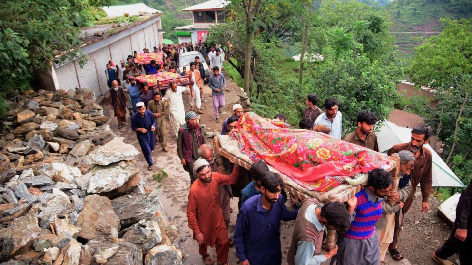
He described the disaster as “the biggest and worst calamity” in the history of the district. Muhib shared that more than half of the Pir Baba Bazaar — the district’s main marketplace — had been submerged, resulting in losses worth billions of rupees. Entire villages, he said, were “gulped down by the floods”, leaving devastation in their wake.
“In every household, four to five people were swept away in the flash floods,” Rasheed recounted on a phone call with Dawn.com, his voice heavy with grief. “There are some families that have been completely wiped out. In one village, a funeral for 40 members of a single family was offered collectively.”
Rasheed also lamented the lack of government support. “Officials are only visiting the area for pictures and photos, not to provide any real help to us,” he said. In the absence of external aid, locals have been forced to help themselves, but their resources are running thin.
“There is a shortage of medicines, food, and other essentials, but the roads are blocked, and there are no mobile phone signals,” he added.
The devastation in Buner has put residents of neighbouring districts, located in the south at a short distance and unscathed from the floods so far, in a perpetual state of anxiety.
Zubair Torawali, a resident of Bahrain in Swat, said that even though his area has not yet been directly hit this year, the fear is palpable. “If the floods reach us, it could mean huge losses,” he said, explaining how villagers anxiously watch the rains shift from north to south every monsoon season.
In the end, it is always the people who pay the price — losing homes, livelihoods, and loved ones — while the state fails to act on lessons learned. Year after year, the water returns. And with it, the losses.