January 13, 2025
SAMRANG/SAMDRUPJONGKHAR – For decades, the community along the Samrang River in Samdrupjongkhar has been living in a constant state of fear, especially each monsoon season when the swollen river threatens to flood their homes and farmland.
Lakmon Rai, 63, a resident of Samrang, remembers how two decades ago he lost about four acres of agricultural land to a devastating flood. Despite the construction of a gabion wall to protect the community, the river’s shifting course has intensified the risks.
“Every monsoon, the river changes its path and flows toward our village,” said Lakmon Rai, who lives just 70 metres from the riverbank.
He and his fellow villagers, many of whom live in the lower parts of Samrang, have seen more than 100 acres of land lost to floods over the past two decades. For most of them, their once-productive land is now buried beneath layers of sand and debris.
Not only Lakmon Rai, many residents in the lower part of Samrang village live in constant fear of the swollen river. “During monsoon, we can’t sleep in peace. Many households are located near the river and every monsoon, the farmers are terrified,” he said.
Although the local government officials and the members of the parliament (MP) are aware of the problem, not much has been done to reduce risk to our livelihoods.”
In 2012, the gewog administration constructed a two-metre-high and 700 metres length gabion wall. But the wall gets submerged under water due to debris deposit during the monsoon.
“Water then overflows to our village that is lower than the river bank,” said a resident, Karma Wangchuk.
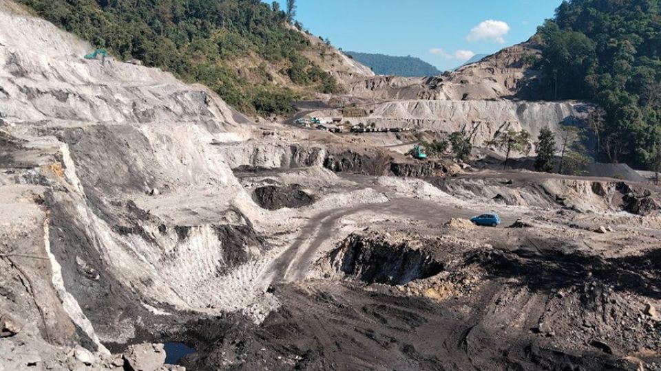
The issue, residents say, has worsened since the State Mining Corporation Limited (SMCL) began its operations upstream. Locals say that mining activities have exacerbated erosion, shifting debris into the river and raising the riverbed, which now often overflows during the monsoon.
“Since the mining started, we have seen debris fill the riverbed,” said Karma Wangchuk. “Now, every monsoon, we have to stay up all night guarding the river’s flow, terrified of losing our land and livestock.”
Former Gup M.B. Gurung said that mining had made the situation worse, claiming the riverbed has risen above the level of the village, causing further risk to the community.
“While natural factors contribute to the problem, the overburden from the mining operation is clearly exacerbating the situation,” he said. “The river is now diverting into the village, and we need urgent intervention.”
Overburden refers to the layers of soil, rock, and other materials that lie above a mineral deposit or coal seam, which must be removed to access the valuable resources beneath.
Despite numerous complaints to SMCL, local officials, and even their elected representatives, villagers say they have seen little progress toward a permanent solution.
“We need proper flood protection walls that can handle the rising threat,” one resident explained.
Samrang Gup Jigme Singye Drukpa said that the flood risk has been increasing by the year.
“We have informed the government and SMCL about the threat, urging them to deposit the overburden along the river to act as a barrier, but nothing has changed,” he said. “With each heavy rainfall, the debris from mining operations flows downstream, threatening us further.”
SMCL, on the other hand, claims that around 90 percent of the debris contributing to the flood risk is from natural landslides. Mining activities, according to SMCL, are responsible for only 10 percent of the debris increase.
“We carry out dredging and excavation during the monsoon and try to manage the river’s flow,” said Jigme Dorji, interim site manager of Habrang Coal Mine, which operates near Samrang.
“It is not a task that SMCL can undertake alone. Relevant agencies and authorities must be involved to solve the problem,” said an official from SMCL. “We are willing to contribute to building the protection wall and more, but we can’t bear the full financial burden.”
Kuensel learned that after people complained about the river encroaching on their villages, the Dungpa, local leaders, officials from SMCL, and a few villagers inspected the area. However, no concrete solution has been reached as of today.
Tshophangma Coal Mine has three designated overburden dump yards, of which two are no longer used for dumping. The third dump yard, located on the west side of the mine, is currently in use.
Officials from the Department of Environment and Climate Change (DECC) stated that the overburden dump yards have been maintained.
“It was observed that there is an existing natural slide upstream of the Samrang River on the right bank of the Tshophangma Coal Mine, which could be the main source of debris deposition in the river,” an official said.
According to the DECC, there are no records of major breaches of environmental rules and regulations to date. “We conducted compliance monitoring, and the report is yet to be finalised. The report will guide the ministry regarding any observations of non-compliance with laws, rules, and regulations,” the official added.
The Department of Geology and Mines (DGM) oversees the drilling, blasting, and excavation to ensure they meet the standards of the Mines and Minerals Management Act (1995), MMMR (2022), and adhere to the approved Final Mine Feasibility Study (FMFS) and Environment Management Plan (EMP), ensuring the stability of the mining area.
A DGM official said that controlled blasting is conducted to lessen the impacts on the surrounding areas, thereby decreasing the risk of erosion in lowland regions.
“The nearest settlement lies more than four kilometres from the mining site, and our assessments show that the impact of soil erosion on the community is minimal,” said the official.


