
April 21, 2025
THIMPHU – Forest fires have destroyed around 70,696 acres of forest land across the country in the past five years, according to records with the Department of Forests and Park Services (DoFPS).
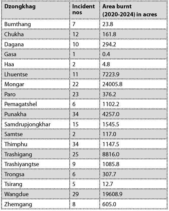
From 2020 to 2024, some 261 separate forest fire incidents were recorded in the country.
The forest fire data shows regional, intensity and frequency differences in forest fire incidents and the extent of forest loss. While some districts experienced frequent but smaller fires, others saw fewer incidents with devastating impact.
In the eastern region, Mongar was the worst affected, losing over 24,005 acres of forest to 22 incidents in the past five years. This means each fire, on average, consumed more than 1,000 acres, by far the highest in the country.
Wangdue followed closely with 19,608 acres burned, and Lhuntse reported 7,223 acres destroyed by 11 fires.
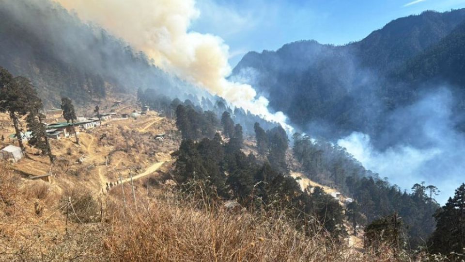
VISUALS: KUENSEL
VISUALS: KUENSEL
Trashigang and Punakha rounded out the top five most affected districts in terms of area burnt, with 8,816 acres and 4,257 acres lost, respectively. In terms of frequency, Thimphu and Punakha each recorded 34 incidents, the highest among all districts. However, the total area burnt in Thimphu was significantly lower at 1,147.5 acres, suggesting that most fires were likely detected and contained early.
At the other end of the spectrum, Gasa, Haa, and Tsirang reported some of the lowest figures. Gasa had only one fire incident in five years, burning just 0.4 acres. Similarly, Tsirang and Haa recorded only 12.7 and 4.8 acres burnt, respectively.
One of the key insights from the data is the disproportionate damage caused by fewer fires in certain regions. Districts like Mongar, Wangdue, and Lhuntse demonstrate a trend of high-intensity wildfires that could be harder to detect early or access for firefighting.
Conversely, dzongkhags like Chukha and Thimphu had more frequent fires but with relatively minimal area burnt.
A DoFPS official said that forest fires in the eastern region were harder and took longer to contain due to the dominant chirpine forests, which are highly flammable and prone to ignition. “The rugged terrain and inaccessibility, along with the resinous nature of the trees, made firefighting efforts even more difficult.”
In contrast, the forests in the northern region, which are moister and cooler, are less susceptible to fire. And while blue pine forests in the western region are susceptible, a stronger network of responders, including firefighters, volunteers, and government agencies, has kept fires largely in check.
“The Inter-Agency Forest Fire Coordinating Group is operational nationwide, but the main difference between the east and west lies in manpower. We are working to strengthen fire response teams and community groups in all regions to improve early detection and containment. Once a fire spreads, it becomes very difficult to control,” the official said.
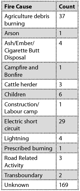
Despite the scale of destruction, the cause of 64 percent of forest fires remains unknown. Of the 261 recorded incidents nationwide, 169 forest fires had undetermined origins, yet they accounted for nearly 62,327 acres, or 87 percent of the total forest loss.
The DoFPS official acknowledged the high number of unknown causes as a significant concern. “It is difficult to ascertain or confirm the cause of fire due to a lack of evidence, as most evidence is destroyed in the fire. However, whenever a culprit is caught, penalties have been imposed,” the official said.
Under the Forest and Nature Conservation Rules and Regulations, 2023, setting fire to state forest land is a punishable offence, with fines starting at Nu 200 per acre burned and Nu 100 per tree damaged.
“To prevent future disasters, we must improve fire cause investigation, especially in areas with repeated incidents. Strengthening forensic capacity and community-based reporting could help reduce these unknowns,” the official said.
He added that fires caused by human negligence, such as agricultural burning or electrical faults, are especially troubling because they were largely preventable.
Among the known causes, agricultural debris burning was the most common, responsible for 37 incidents that destroyed 1,644 acres. However, the most destructive were suspected electrical short circuits, linked to 29 fires that razed 6,531 acres of forest.
Fires caused by children led to six incidents, destroying 323.2 acres, while road-related activities were responsible for three fires burning 178.5 acres. Natural causes like lightning accounted for four incidents and around 378.8 acres of burnt forest.
Other lesser causes included careless disposal of ash or cigarettes (four incidents), cattle herding (three incidents), campfires, construction sites, and controlled burning, each responsible for one fire. Even transboundary fires were reported twice, resulting in a combined loss of nearly 21 acres.