September 24, 2025
PHNOM PENH – The Ministry of National Defence has firmly rejected Thailand’s use of border post location maps to claim Cambodian territory, accusing the Thai military, provincial authorities and media of misleading the public with unilaterally drawn documents.
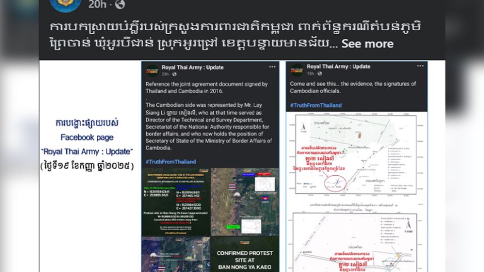
Chheng Khun, deputy director of the ministry’s Department of Geography, explained that the Royal Thai Army, the Sa Kaeo provincial administration and several Thai media outlets have disseminated maps, satellite images and model layouts which suggest that Cambodia officially recognised the border line in the Prey Chan village area, located between border posts 42 and 43.
“On September 19, 2025, the Royal Thai Army’s Facebook page posted information aimed at creating confusion, claiming that the head of the Cambodian survey team had signed to recognise the border line,” the ministry said.
“This is not true,” it added.
According to the ministry, the document cited by Thailand was merely a verification of the locations of the border posts, jointly signed during past inspections by Cambodian and Thai survey teams to confirm posts originally set during the French colonial era.
“These are not maps or documents that specify the border line,” Khun stressed.
The ministry underlined that the blue and red connecting lines shown on Thailand’s satellite map were added unilaterally and “do not represent any officially agreed-upon boundary”.
Khun said these additions were intended to confuse and incite demands for recognition of a border line that has never been bilaterally endorsed.
He noted that while Thailand accused Cambodian villagers of encroachment, its maps ignored areas where Thai civilians and soldiers had themselves occupied Cambodian land.
Ground surveys, he said, confirmed that Thai nationals were benefiting from Cambodian territory.
The ministry also raised concerns over Thailand’s apparent breach of confidentiality in ongoing border negotiations.
Under the framework of the Joint Boundary Commission (JBC), both sides had agreed to keep all negotiation-related documents confidential. Cambodia, it said, had always respected this principle.
Thailand’s repeated use of the document as an official border map violates the spirit of confidentiality and risks escalating tensions.
Phnom Penh has called on Thailand — including its military, local authorities and relevant institutions — to cease using unofficial maps or satellite imagery that distort the facts and create misunderstandings.
The ministry urged respect for past agreements, particularly the outcomes of the Cambodia–Thailand General Border Committee (GBC) special meeting on September 10, which tasked the JBC with finding peaceful solutions.
“Cambodia continues to uphold peaceful negotiations in line with international law,” the ministry reiterated.
Cambodia seeks solutions to border issues and avoid actions that undermine trust, create misunderstandings, cause tension and expand the scope of border disputes, it explained.