March 7, 2024
BENGUET – Climate change is increasingly making its presence felt in areas with the coolest climate in Luzon environmentally and economically.
Among these areas is Baguio City, undoubtedly among the top destinations for those seeking respite from the humid climate of Metro Manila and other regions in Luzon, especially as the dry season approaches.
Back in the 1970s and 1980s, construction went into full swing to make the three main access roads leading to Baguio—Kennon Road, Marcos Highway, and the longest but safest route Naguilian Highway—safe for travelers and motorists.
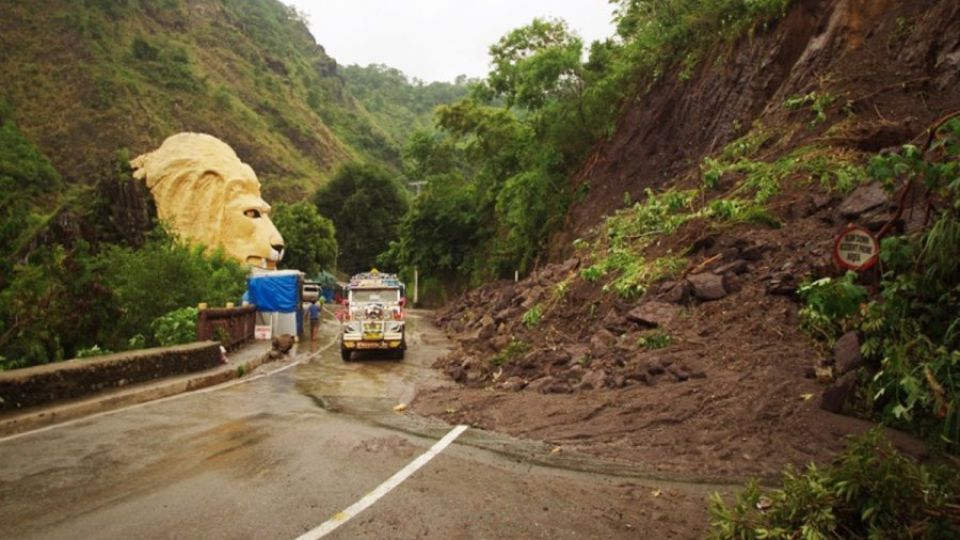
Kennon Road offers the fastest route for driving up to the summer capital and starts from Rosario, La Union province, winding through a narrow and steep valley. But it is perceived to be the most dangerous among the three routes, especially prone to landslides during the rainy season.
The Department of Public Works and Highways in the Cordillera Administrative Region, in coordination with local governments here, decided to close down this scenic route due to landslides that happen even when there’s no typhoon. Landslides have become an all-year round occurrence, some locals told INQUIRER.net.
Nasa study
The National Aeronautics and Space Administration (Nasa) released a study in October 2022, highlighting a concerning trend as climate change continued to alter Earth’s weather patterns—a rise in the frequency of landslides brought by heavy rain events.
The study, published in a feature article titled “Nasa Study Finds Climate Extremes Affect Landslides in Surprising Ways” on the Nasa website, focused on the dramatic impact of fluctuating rain patterns on the behavior of slow-moving landslides.
Climate change is making these cycles more common worldwide, with alternating periods of drought and strong storms, Nasa said.
The study showed that, contrary to predictions, landslides showed similar susceptibility to precipitation extremes in both wet and dry areas. Climate change is driving more volatile precipitation patterns around the world—very dry stretches punctuated by storms that drop large amounts of rain or snow in a short amount of time.
It also underlined the need to understand how landslides respond to extreme weather events, as well as the critical role of water in causing them. “Water triggers landslides, and knowing how landslides react to record droughts or extreme rainfall can help researchers better predict their future behavior, including whether any could collapse, or fail catastrophically,” according to the article.
Effects are not immediate
The study also revealed that low-moving landslides may not immediately endanger infrastructure or people, but over time, they can damage or destroy buildings, roads, and other structures. Unexpected collapses can happen, presenting serious risks to residents.
READ: Landslides destroy roads, homes as rains pummel Cordillera
According to another Nasa article, rising temperatures are predicted to increase the frequency and intensity of downpour events, which may worsen landslide activity in vulnerable areas. It warned that “more frequent and intense rainfall events due to climate change could cause more landslides…”
READ: Rainfall alone didn’t cause landslide, flooding in Mindanao
These findings have particularly concerning implications for regions that frequently see high levels of precipitation, such as those experiencing monsoon seasons from June to September. Such rainfall can cause landslides, which can have disastrous effects ranging from the devastation of entire communities to the interruption of vital utilities like transportation and drinking water supply.
The findings of Nasa’s study are a sobering reminder of the pressing need for preventive action to lessen the effects of climate change and safeguard vulnerable areas from landslide catastrophes.
Kennon Road’s economy
Kennon Road presented a different appearance when INQUIRER.net visited Benguet at the start of this month. The rubble and debris may not be visible on the road but visitors were like “re-routed” back in time.
There is a long stretch of Kennon Road in Camp 6, Tuba, that is completely shut, prompting motorists to take the risk of driving off-road and traversing rivers.
READ: ‘Kennon Road needs rest for five years’
The closure of Kennon Road to public transport, which is only open during specific hours and days, is adversely affecting local tourism. The picturesque Lion’s Head, usually bustling with visitors seeking that perfect Instagram pose, and its souvenir shops no longer exude their former vibrancy.
RELATED STORY: Davao de Oro town landslide due to natural causes, says MGB exec
National and local governments are suggesting the use of Marcos Highway and motorists face risks if they chose to use Kennon Road during the window hours. Even during the recent Panagbenga festival, no commercial transportation was allowed to pass Kennon Road.
RELATED STORY: 2 killed, 4 hurt in Kennon landslide
There’s a lot of debate about climate change, skeptics say it is just for political publicity while some insist it is real and it is here. However, science backed by satellite images is sharing tell-tale signs that changing climate is already happening.


