
April 26, 2023
PETALING JAYA – It’s been crazy weather in the country, with stiflingly hot, arid days and sweltering afternoons in some parts, followed by downpours and thunderstorms in the evening in others.
It’s likely to stay that way for the next week or so, say weather experts.
Several parts of the country have seen temperatures soar above the 36°C heatwave level earlier this week with the Meteorological Department (MetMalaysia) forecasting the mercury to hover at about 35°C in most parts of the country daily until early May.
The east coast states are facing droughts, the dam levels are falling in Penang, but in the Klang Valley, evening thunderstorms are causing havoc, even landslides.
Fellow at Academy of Sciences Malaysia Dr Fredolin Tangang said that thunderstorms were typical during the inter-monsoon periods that the country was currently facing.
“The current hot and dry spell is likely due to the suppressed convection associated with Madden-Julian Oscillation (MJO) which is likely to continue for about a week or two,” he said yesterday.
He explained that MJO is a mode of climate variability that occurs due to atmosphere and ocean interaction.

“It typically occurs once in 20 to 60 days. While its current effect is hot and dry spells over our region, its enhanced convection can enhance rainfall as well,” he said.
He also said the nation was still in the inter-monsoon period between April and May where winds are weaker and not blowing in any particular direction.
“Daytime heat can make way for afternoon and evening thunderstorms, particularly in the west of the peninsula and Klang Valley,” he added.
According to MetMalaysia, Perlis is expected to have 35°C temperatures until May 1 while Kelantan, Pahang, Perak and Kuala Lumpur are expected to be at around 34°C in the same time period.
The other states, including Sabah and Sarawak, will average around 33°C during the day in the coming week or so.
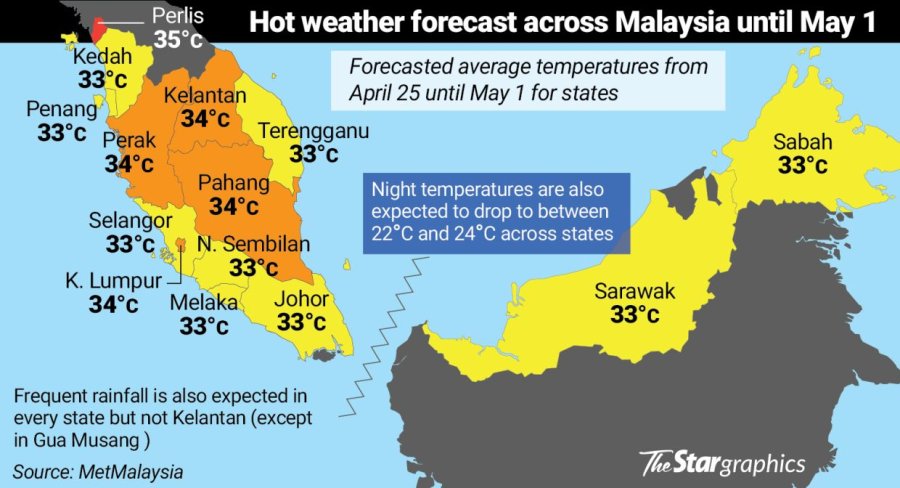
Night temperatures are expected to average at 24°C in Perlis, Kuala Lumpur, Negri Sembilan, Johor, Selangor and Melaka throughout the week.
The remaining states’ night temperatures were forecast to be a chilly 23°C on average with Sabah, in particular, expected to go as low as 22°C.
Senior lecturer at Universiti Malaya’s Department of Geography Dr Sheeba Chenoli also attributed the current weather to the MJO.
She said the weather is expected to get drier as the inter-monsoon period gives way to the southwest monsoon.
The phenomenon is not just in Malaysia. The hot weather, she said, was also felt in other countries in the region, particularly Laos, Thailand and Myanmar. She said these countries could expect even drier conditions in the coming months.
Universiti Malaya meteorologist and climatologist Prof Datuk Dr Azizan Abu Samah said the weather was expected to remain hot, particularly in north of the peninsula.
“Kedah and Perlis now have hot days with cloudless mornings and thunderstorms in the evenings,” he said.