

June 23, 2026
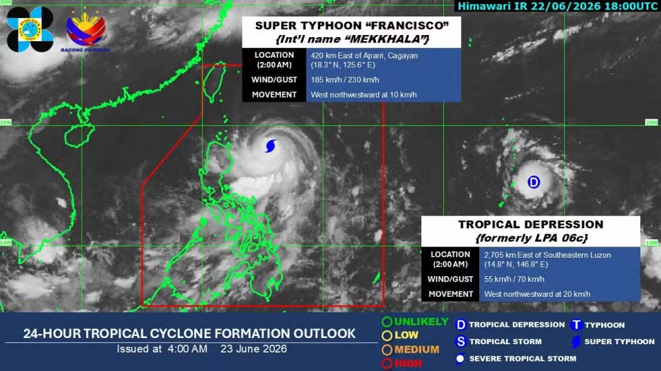
MANILA – Super Typhoon Francisco slowed down over the Philippine Sea east of Cagayan while maintaining its strength Tuesday, prompting the continued implementation of Tropical Cyclone Wind Signal (TCWS) No. 1 in parts of Northern Luzon.
According to the Philippine Atmospheric, Geophysical and Astronomical Services Administration (Pagasa), Francisco was estimated at 410 kilometers east of Aparri, Cagayan, carrying maximum sustained winds of 185 kilometers per hour (kph) near the center and gusts of up to 230 kph.
The cyclone was moving west northwestward at 10 kph from a previous speed of 15 kph.
TCWS No. 1 remains in effect over the following areas:
- Batanes
- the northeastern portion of Cagayan (Santa Ana and Gonzaga)
- the eastern portion of the Babuyan Islands (Babuyan Is., Didicas Is., Camiguin Is.)
Francisco’s track
Pagasa weather specialist Veronica Torres said Francisco is expected to slow further before eventually curving away from the country.
“We expect the typhoon to continue slowing down until Wednesday morning as it moves along a north-northwestward track,” Torres said.
“Francisco may still intensify or maintain its current strength through this afternoon before gradually weakening,” she added.
Pagasa said the super typhoon is expected to remain far from the Philippine landmass.
Weather today
This Tuesday, Francisco will bring rains with gusty winds over Batanes and Babuyan Islands while cloudy skies with rain showers and thunderstorms are expected in Aurora, Isabela, and mainland Cagayan.
Meanwhile, Francisco continues to enhance the southwest monsoon or habagat, which is expected to bring gusty conditions across several parts of the country.
Calabarzon, Mimaropa, Bicol Region, Visayas, and Mindanao will see cloudy skies with scattered rains and thunderstorms because of the habagat.
Moreover, Metro Manila and the rest of Luzon will experience partly cloudy to cloudy skies with isolated rains due to localized thunderstorms.
Another cyclone outside PAR
Pagasa is also monitoring a tropical depression outside PAR.
As of 3 a.m., it was located 2,680 kilometers east of Southeastern Luzon, with maximum sustained winds of 55 kph and gusts of up to 70 kph.
The system was moving west northwestward at 20 kph.
While the weather disturbance may eventually enter PAR, Pagasa said it is not expected to directly affect the country based on current forecasts.
The weather bureau advised fisherfolk and operators of small sea vessels to exercise caution, especially in waters off Northern Luzon, where rough sea conditions may develop./dp