January 28, 2026
JAKARTA – Poor oversight of plantations and urban developments in the mountainous northern Bandung region have reduced the area’s water absorption capacity, a factor academics and environmental groups say contributed to a deadly landslide in Pasirlangu village in West Bandung, West Java
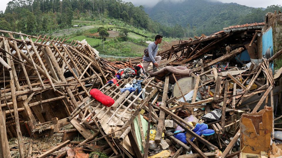
Triggered by heavy rainfall across parts of Java in the past weeks, landslides struck West Bandung on early Saturday at around 3 a.m., burying some 30 homes on the slopes of Mount Burangreng.
As disaster response continued on Tuesday, the National Disaster Mitigation Agency (BNPB) identified 20 fatalities from the 38 body bags recovered, while dozens of people remain missing. Meanwhile, more than 600 residents were forced to flee for their safety.
Environmental group Indonesian Forum for the Environment (Walhi) criticized the local government for failing to control extensive land-use conversion in the North Bandung Area, including West Bandung, warning that the resulting loss of water catchment areas worsened the impact of the landslide.
“The landslide in Pasirlangu is the result of years of neglect by both the regency and provincial administrations, which for 15 to 20 years failed to exercise proper control and oversight of the water catchment area,” Walhi’s West Java chapter executive director Wahyudin Iwang told The Jakarta Post on Tuesday.
He said the group had long warned authorities of the risk of allowing property developments for residential and tourism purposes, as well as plantations in the area, many of which he claimed operated with inadequate supervision.
While acknowledging that the West Java administration has issued some regulations to halt land-use permits in the North Bandung area, Wahyudin said the measures remained insufficient.
“They must be followed by concrete efforts to strengthen the area’s function as a water catchment zone through reforestation and ecological restoration,” he added.
The North Bandung Area, which spans Bandung and Cimahi cities as well as Bandung and West Bandung regencies, was designated as a provincial strategic area in 2016 to protect it from excessive development, given its role in water conservation and ecosystem balance.
Trisakti University urban planning expert Yayat Supriyatna said weak oversight also extended to flawed spatial planning for agriculture activities on the slopes of Mount Burangreng.
“Cultivation areas overlap spatially with protected zones that have lost significant tree cover, even though these areas are supposed to function as water catchment zones to protect settlements below,” he said on Tuesday.
Arguing that provincial spatial planning policies remained inadequate, Yayat urged preventive mitigation measures, including installing clear warning signs in landslide- and disaster-prone areas and enforcing restrictions on agriculture and residential development.
An analysis by the Geological Agency at the Energy and Mineral Resources Ministry found that the landslides resulted from an “interaction between geological conditions, steep morphology and land use as well as the triggering factor of heavy rainfall.”
The agency noted the area has undergone weathering that increases landslide susceptibility, while the dominance of residential development, agricultural activity and inadequate drainage systems had further heightened the risk of ground movement.
West Java Deputy Governor Erwan Setiawan said the province would take firm action against those responsible for illegal land-use conversion in forest areas managed by state-owned forestry company Perhutani in West Bandung.
“[Since] this is forest land, not agricultural land, we will make it green again, and return it to its designated function as forest,” Erwan said on Sunday, as quoted by state news agency Antara.
Meanwhile, Environment Minister Hanif Faisol Nurofiq said his ministry would prioritize environmental restoration and improvements to landscape spatial planning as part of a long-term effort to strengthen ecological functions in the region.
“Sustainable spatial planning and the restoration of vegetation on critical slopes are long-term solutions that are no longer negotiable,” Hanif said on Sunday, adding that experts have been deployed to assess the causes of the landslide and prevent similar disasters.
The minister acknowledged that, in addition to heavy rainfall that reached 68 millimeters in the past week, hillside land clearing for agriculture that ignored environmental sustainability has increased landslide risks.