

October 1, 2018
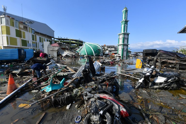
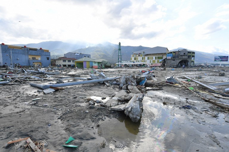
A 7,4-magnitude earthquake and subsequent tsunami struck central Indonesia on Friday causing widespread destruction.
The death toll from the earthquake in Palu and Donggala, Central Sulawesi has risen to 832, the National Disaster Mitigation Agency (BNPB) announced on Sunday afternoon. Around 821 victims have been found in Palu, while the rest have been found in Donggala.
The agency has also recorded that at least 540 people were injured by the earthquake and tsunami, and are currently being treated in hospitals. Meanwhile, 16,372 people are reportedly displaced and are currently occupying 24 camps around the region.
BNPB spokesperson Sutopo Purwo Nugroho said that the death toll was likely to rise given that rescuers had yet to identify or find many victims, or even reach some disaster-stricken areas.
Most of the deaths resulted from people being buried under rubble or being struck by the tsunami. The police held prompt and proper burials for the deceased after identifying them using the Disaster Victim Identification method and taking their fingerprints.
Thousands more fear dead
A number of areas in Central Sulawesi were hit by large amounts of mudflow following the 7.4-magnitude earthquake. Petobo subdistrict in South Palu district, Palu, which is located 10-kilometers from the sea, has been struck by such mudflow. It is feared that about 2,000 people in the subdistrict are dead, with homes having been dragged away by the mud.
Mobile phone footage of the mudflow circulated online on Sunday, showing several buildings being dragged. The video was accompanied by a broadcast message saying the incident occurred in Jono Oge village in Sigi regency on Saturday afternoon.
The person recording the event could be heard saying, “Oh Jesus Christ,” while the houses before him were moving.
Another video posted on Twitter shows people running and houses collapsing because of liquefaction in an unidentified location in Palu.
National Disaster Mitigation Agency (BNPB) spokesman Sutopo Purwo Nugroho said during a press briefing on Sunday in Jakarta that soil liquefaction had occurred, a natural phenomenon that takes place when solid soil loses its strength and behaves like a liquid due to stress such as shaking during an earthquake.
“We observed that such phenomenon had dragged buildings away in several locations, such as in Sigi Biromaru district in Sigi regency and South Palu district,” Sutopo said.
State of emergency declared
The Central Sulawesi administration has declared a 14-day state of emergency over the weekend, according to the National Disaster Mitigation Agency.
Agency spokesman Sutopo Purwo Nugroho said the state of emergency period was declared from Sept. 28 to Oct. 11.
“As the administration has declared the emergency state period, it will be easier for both the regional and national government to mobilize personnel, logistics, equipment as well as money to fulfil the needs of the affected area and people,” Sutopo said during a press briefing on Sunday in Jakarta.
The BNPB will assist the regional administration during the emergency period, especially in relation to disaster fund usage. The government has pledged Rp 560 million (US$37.6 million) in relief funds. The amount might be increased to meet future needs for aid and infrastructure reconstruction.
Apart from the local administrations and BNPB, the team will comprise personnel from the military, police as well as relevant ministries and state institutions.
Many parties have also urged the government to immediately declare the Central Sulawesi earthquake and tsunami a national disaster due to the scale of devastation. As of Sunday, the BNPB had recorded that at least 832 people had died during the disaster.
Sutopo, however, dismissed such suggestions, saying that regional administration offices in the affected area were still intact. “Despite the damage, there are still safe areas.”

Earthquake explained
Indonesia, which sits on the so-called Ring of Fire, is one of the most disaster-prone countries in the world. The 2017 national earthquake map revealed that the number of active faults across the nation has increased from 81 to 295 since 2010.
The Center of Volcanology and Geological Hazard Mitigation has said the deteriorating Palu-Koro fault had amplified the jolt of the 7.4-magnitude earthquake that hit Donggala regency in Central Sulawesi.
The fault is a fracture in the earth’s crust that runs from the Makassar Strait to the northern part of the Boni Gulf in southern Sulawesi. It runs underneath Sulawesi Island.
The fault’s shift is believed to have triggered the major earthquake that struck on Friday.
“The geological map of Central Sulawesi is composed of rocks that are aged between 10,000 and 1 million years. But it fell into decay, causing the jolts to be stronger,” said the institution’s head of earthquake mitigation, Sri Hidayati, on Saturday.
Sri, who is involved in compiling the 2017 Indonesia Earthquake Map, said it was an active fault with a motion that ranged between 30 and 44 millimeters per year.
She added that the agency had sent the map of vulnerable land motion to local governments nationwide.
Sri suggested that local governments should utilize the geological maps as a reference point to implement policies regarding land utilization and spatial development, as well as the construction of earthquake-resistant infrastructures.